

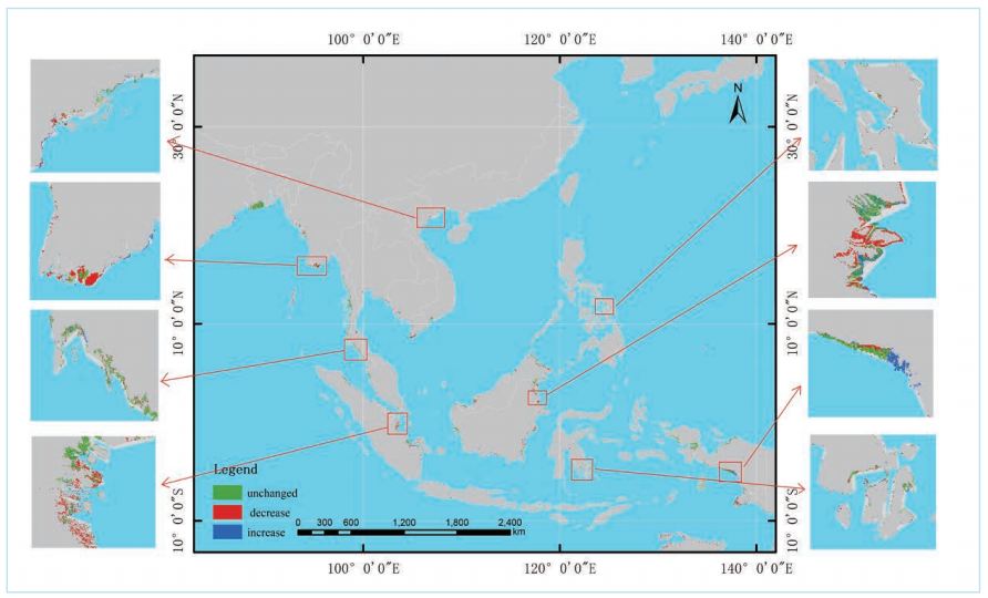

Researchers from the team of “Integration of resource & environment information for island & reefs and surrounding region in South China Sea” from the 3D Digital Ocean Project conducted the work of information extraction surrounding the South China Sea and had made distinct progressing on oil palm and mangrove mapping.
Oil palm is one of the main crops for the Southeast Asia countries. Malaysia and Indonesia are the world's major palm oil exporters. Time-series oil palm mapping can provide important information for ecological and environmental change in Southeast Asia.
Mangrove forests are distributed in the intertidal zone of tropical and subtropical regions and are one of the most valuable coastal ecosystems in the world. Mangrove forests can protect natural coastlines from storms, floods, typhoons, and other disasters. It is also one of the most threatened ecosystems in the world and has declined sharply over the past half-century. Understanding the distribution and change of mangroves in China and Southeast Asia can promote the management and restoration of the mangrove ecosystem which is in urgent need of protection.
Since the tropical regions are cloudy and rainy, long-term sequencing and large-scale vegetation extraction have always been difficult. There exists certain confusion in the spectrum between oil palm and other vegetation (Such as coconut and rubber), while the information extraction of mangrove is often affected by tides. In response to these problems, the research team extracted information for these two types of vegetation based on 30-year time-sequence of mid-resolution image data. Researchers also established the same-season image fusion method, taking advantage of the long-time sequence and continuous data of Landsat images to solve the problems of clouds, rain, and fog. Meanwhile, based on the characteristics of oil palm and mangrove, researchers also selected the appropriate training parameters: In addition to spectral parameters, the topography parameters such as elevation, slope, and aspect are selected for oil palm information extraction while the growth environment parameters such as distance to water and soil quality are selected for mangrove information extraction. Through the above, the large-range automatic information extraction of oil palm and mangrove with the accuracy of over 80% has been achieved.