


The UN’s 2030 Agenda for the Sustainable Development is an important milestone marking the spirit of consensus and cooperation between different nations toward a sustainable future. However, it is facing several challenges in its implementation. Lack of data, insufficient methodology, interconnected and mutually constrained targets, and issues related to localization, are a few select scientific problems that constraint progress. To navigate these issues, the UN established a “Technology Facilitation Mechanism” to encourage technological solutions and to facilitate the support of science, technology, and innovation in formulating viable solutions.
Facing the opportunities brought by such a major challenge, in 2018, the Chinese Academy of Sciences launched Strategic Priority Research Program: Big Earth Data Science Engineering Program (CASEarth), combining the advantages and characteristics of Big Earth Data, targeting 20 indicators of six SDGs including the SDG2 zero hunger that is closely related to the global environment , SDG6 clean drinking water and sanitation facilities, SDG11 sustainable cities and communities, SDG 13 climate action, SDG14 underwater organisms and SDG15 terrestrial organisms, 20 indicators of six SDGs. Have work has been witnessed to integrate multi-source data through different disciplines and cross-integration of knowledge and data between domains. Significant results were achieved in less than a year. Among them, 12 research cases on China were presented in the "Big Earth Data in Support of the Sustainable Development Goals". These cases include the sustainability assessment of the land used for food production nationwide, the overall analysis of the surface water environment in the country, the monitoring and comprehensive evaluation of the progress of urbanization in China, the analysis of the pollution of offshore waters and the health status of marine ecology, and the progress of China's biodiversity protection 12 research cases including the fragmentation of the giant panda's habitat and the assessment of the effectiveness of the conservation of the Qianjiangyuan National Park have been assembled into the "Big Earth Data in Support of the Sustainable Development Goals". State Councilor WANG Yi officially released it to outside in the United Nations.
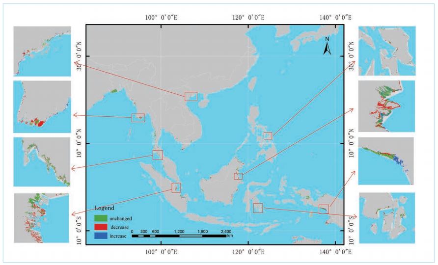
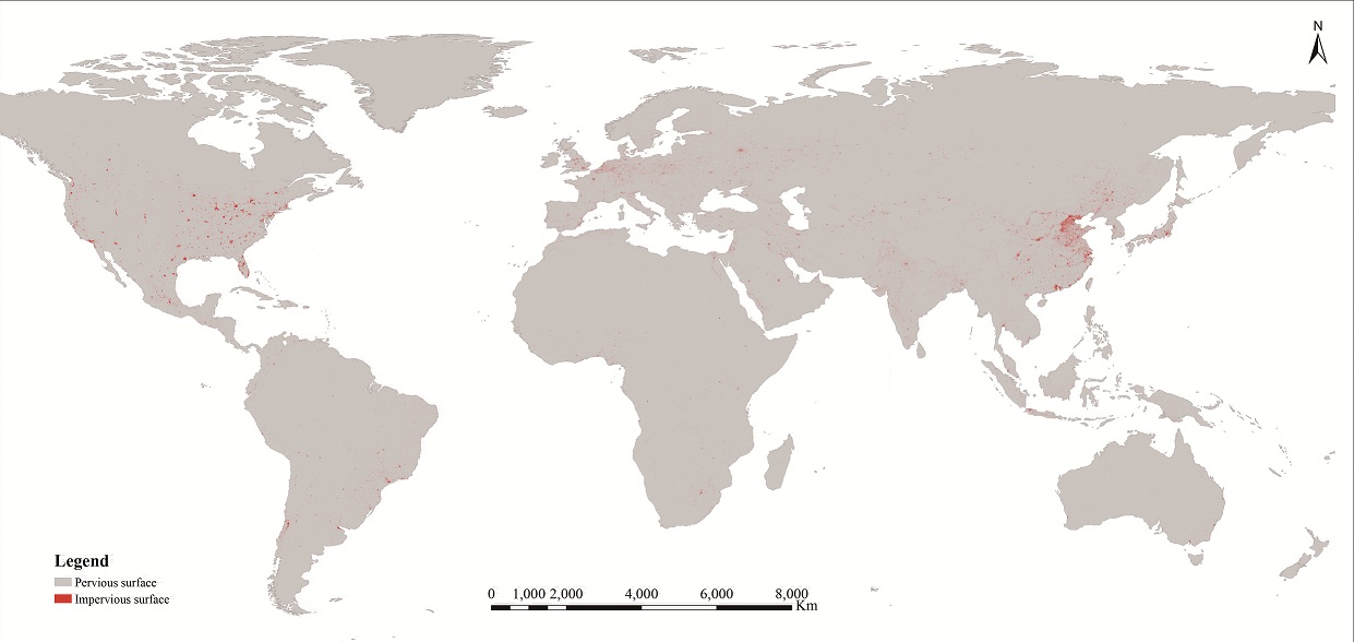
In addition, on global and regional issues such as global land degradation, global urbanization, and glaciers degradation in high Asian basins, there are special cases that use these valuable data and methods to refresh understanding of these important issues. For example, for the important indicators of urbanization monitoring (SDG11.3.1), global 10-meter resolution high-precision urban impervious surface spatial distribution information is use. It proposed to use multi-source multi-temporal elevating rail SAR and optical data to combine its texture and phenological characteristics. The rapid global impervious surface extraction method provides data support for the comprehensive evaluation of sustainable development of Chinese-scale cities.
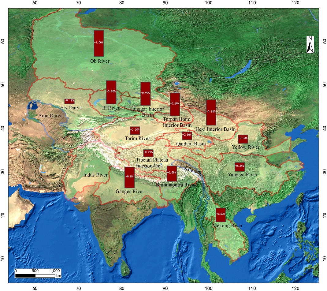
CASEarth uses the fusion of multi-source and multi-phase lifting orbiting synthetic aperture radar (SAR) and optical satellite data and combines its texture and phenological characteristics to propose a global 10-meter resolution impervious surface automatic fine extraction technology to 1500 cities of a population of more than 300,000 people each. The monitoring and evaluation of the indicators of urbanization process every five years in the cities from 1990 to 2015. At present, the public is more concerned about climate change. For example, the change of glaciers under the overall trend of climate change is also a topic often seen in the media. However, what exactly is happening in these glaciers, and what is the specific situation of a glacier, can only be discussed after fully possessing accurate data. Now we have the ability to monitor and analyze changes in high Asian glaciers. Such scientific Big Earth Data is undoubtedly the basic scientific support for formulating relevant management policies and response measures, including predicting and monitoring the water balance of the watershed and improving watershed management. Similarly, the use of big earth data technology also systematically monitors and evaluates the dynamic changes of land resources and biodiversity in ecologically fragile areas. For example, the report case also makes accurate assessment on historical changes, current status, and development directions for the widely distributed oasis ecosystem
The CASEarth Data Sharing Platform further broke through the barriers of data sharing and established an operational data property rights guarantee mechanism and incentive measures. At present, the data platform has released 5PB of data, including ground observation data, bio-ecological data, atmospheric and marine data, basic geographic and ground observation data, biological, microbial and paleontological data, omics data, etc., and will update 3PB per year in the future. The CASEarth platform also brings together a variety of new Big Earth Data analysis methods and models to provide method and tool support for professionals in China and other countries. Indeed, big data technology is rapidly increasing our understanding of the survival and development environment of the planet. What was previously unseen can be seen now; what was originally unclear can now be seen clearly; what was not understood in the past can now be seen from an efficiency and perspective that was previously unimaginable. The high-quality data provided by domestic satellites, the large number of applications of various aerial observation platforms, especially drones, the massive generation of social media data, and the construction of large data centers constitute a revolutionary explosive big data growth trend. If the data in the era of big data is like the oil in the industrial age, the big earth data technology is not only the oil extractor and refinery of data oil, but also the contributor of data oil mines.