


Archaeological and cultural heritage (ACH), one of the core carriers of cultural diversity on our planet, has a direct bearing on the sustainable development of mankind. Documenting and protecting ACH is the common responsibility and duty of all humanity. The conservation of archaeological and cultural heritage is a strategic priority, not only so that cultural property and evidence from the past can be safeguarded and passed on to future generations but also because these are valuable assets whose exploitation supports the UN's 2030 Sustainable Development Goals (SDGs).
By taking advantage of the fast imaging, large-spatial coverage, high spatial and spectral resolution and signal sensitivity to anomalies linked to exposed and subsurface features that aerial and spaceborne remote sensing (ASRS) provides, ASRS can be successfully adopted for use in ACH applications. ACH is one of the fields in which remote sensing from elevated points was first used - the use of kites was followed by hot-air balloons, aircrafts and helicopters, shuttles, rockets, space stations and finally satellites (Figure. 1), and archaeological remote sensing arisen under this historic context in the beginning of the 20th century. Using each of these platforms, archaeologists and specialists have recognized the great value of multi-platform remote sensing in gaining a view from above in order to better identify and understand ACH sites and their wider environments.

Fig. 1. The schematic diagram of remote sensing (RS) for ACH applications.
Through more than one century development and practice, ASRS has become one of the indispensable tools in the field of archaeology. However, with the diversified development of earth observation science and technology in archaeology and cultural heritage, the complexed problem of "two skins" between remote sensing and archaeology has become increasingly apparent. In addition to the major issues of slow technological innovation, limited and single data source and insufficient computing resources, remote sensing archaeology has encountered unprecedented development bottlenecks in the early 21st century.
In the face of the urgent "two skins" issue of remote sensing and archaeology, the novel space-air-ground integrated sciences and technologies that can obtain the Big Earth Data (BED) is becoming a sharp tool to ACH applications. Under the support of the Strategic Priority Research Program of CAS, CASEarth, the CAS’s researchers began to comprehensively use the BED science and technology to carry out the comprehensive scientific research and practice to archeology and cultural heritage with the new space-air-ground integrated model. CAS’s researchers carried out extensive international cooperation and exchange with many scientific organizations and institutions at home and abroad, and made a series of important original achievements, and gradually took the lead in the world. These new development trends in remote sensing archaeology provide the necessary case practice and theoretical accumulation for the birth of “Space Archaeology” which is one of the major objectives of the sub-project of Cultural and Natural Heritage Conservation and Sustainable Development, Digital Belt and Road (DBAR-Heritage) under the CASEarth Program. The core is to establish a discipline system of “Space Archaeology” in the world and seize the commanding heights of the discipline construction and scientific research.
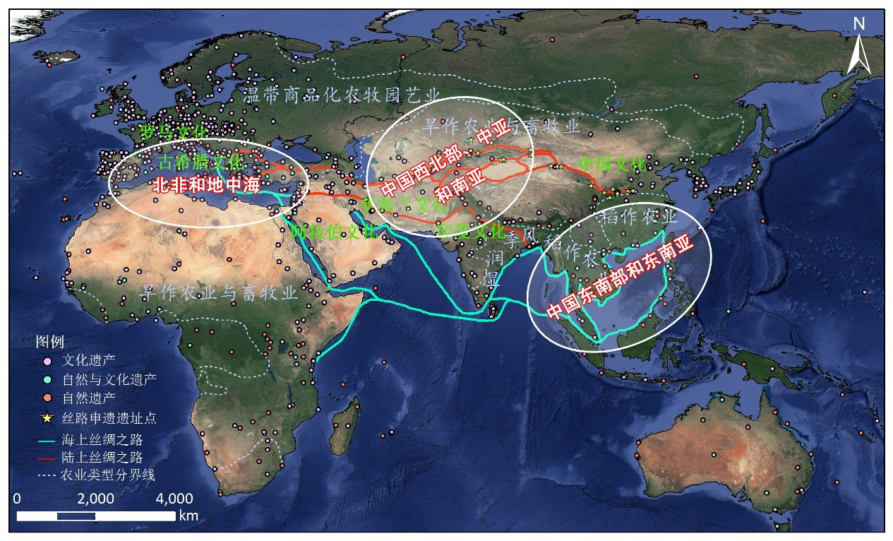
Under the leadership of Prof. Guo Huadong, Chair of the CASEarth Program and Prof. Wang Xinyuan, the P.I. of the DBAR-Heritage sub-project, the Space Archaeology research group established extensive cooperation with more than 10 international organizations and institutions in the BAR’s countries such as Pakistan, Tunisia, Cambodia, Italy, Myanmar, Kazakhstan, Mongolia, Netherland, Sri Lanka, Greece and Cyprus. In 2017, the DBAR-Heritage Int’l Working Group was launched in Beijing, and the DBAR-Heritage given priority to 3 key regions of Northwest China and Central and South Asia, North Africa and the Mediterranean Region, Southeast China and Southeast Asia (Figure 2). The DBAR-heritage is aiming to promote the innovation of BED sciences and technologies in the field of Archaeology and Cultural Heritage. After three years of vigorous development, through the deep practice and wide application of employing space-air-ground integrated ASRS in the BAR, a new paradigm is gradually formed, which will push Remote Sensing Archaeology to a new stage of Space Archaeology.
Major Achievements
Based on the archaeological practical exploration and theoretical accumulation over the past 20 years, especially since the launch of CASEarth Program in 2017, combined with more than 10 successful pilot cases in Asia, Europe, Africa and America, the CAS’s space archaeology research team systematically reviewed and summarized the development process of remote sensing archaeology in the past 110 years, and for the first time comprehensively elaborated and refined the application principle, research progress and current situation at home and abroad, advantages and disadvantages, problems and challenges faced by diverse archaeological remote sensing technologies of field archaeology, ground remote sensing, geophysical prospection, photogrammetry, multispectral and hyperspectral, SAR and Lidar, and proposed solutions and the suggestions for challenges are put forward. The research results were invited and published in journal of Remote Sensing of Environment in the form of review articles. In the background of the new generation of Digital Earth and BED, in this review, CAS’s researchers put forward five new directions of space information technology in the field of archaeology and cultural heritage in the 21st century for the first time: towards automatic identification and artificial intelligence (AI), towards BED and cloud computing, and towards the complex of ACH sites and their supporting environments. The review marked the realization of historic leap from Remote Sensing Archaeology in the 20th century to Space Archaeology in the 21st century.
A series of original achievements have been made in the research of space archaeology theory and practice under the support of the CASEarth Program. In the past three years, the space archaeology research group has published 10 plus Top 25% SCIE covered papers concerning archaeological prospecting and cultural heritage monitoring and protection. Through further theoretical refinement, the basic research framework of space archaeology has been formed, and the monograph of Introduction to Space Archaeology has been compiled, which will be published in both Chinese and English. In Manual of Digital Earth, the research group led to write and complete the chapter of Digital Heritage, presenting the main theoretical and practical technologies and pilot cases of space archaeology and digital heritage, and putting forward the development trend of digital heritage in the future. Additionally, in order to meet the UN’s SDGs 2030 Target 11.4 “strengthen efforts to protect and safeguard the world cultural and natural heritage”, the space archaeology research group put forward a new evaluation indicator, and provide a pilot case which becomes one of the 12 typical cases in the CAS’s report on BED in support of the Sustainable Development Goals. The report was officially released at the 74th UN General Assembly in 2019.
Space Archaeology of Silk Road
The Silk Road is precious cultural heritage owned and shared by all mankind. To enhance the ability to rescue archaeological discoveries, space archaeology provides new technical methods for the detection, discovery and reconstruction of sites along the Silk Road at different scales. With the benefit of spatial information technology, a spatial forecast model of heritages based on GIS spatial analysis was built by CAS’s space archaeology research group by considering the similarity of environmental and geomorphological landscapes of the ancient Silk Road between northwest China and southern Tunisia using satellite imagery, historical documents, archaeological survey data and other multivariate data. Three ancient city sites related to old stages in Dunhuang, northwest China, were discovered on the high-resolution satellite remote sensing imagery. The field archaeological survey supported by GPS technologies and historical research material confirmed the specific locations of the ancient stages. Based on the Digital Earth platform and existing spatial archaeological results, the postal system between Guazhou and Shazhou (two prefectures) in the period of the post-Wuhou Tianshou second year (A.D. 691) was digitally reconstructed (Figure 3a). It laid a scientific database foundation to study the route of the ancient Silk Road and the changes in the ancient oasis in medieval China. The new paradigm of spatial archaeology has been promoted and applied to Tunisia, where 10 ancient Roman remains have been discovered; the legacy evidence chain reflected the military defense system of the southern frontiers of the Roman Empire (Figure 3b). The comparative space archaeological study of the defense system along the Silk Road between the Han Great Wall and the Roman Lima system provides detailed knowledge of the defense system, border defense strategy, human-land relationship and environmental changes in areas along the Silk Road as scientific references.
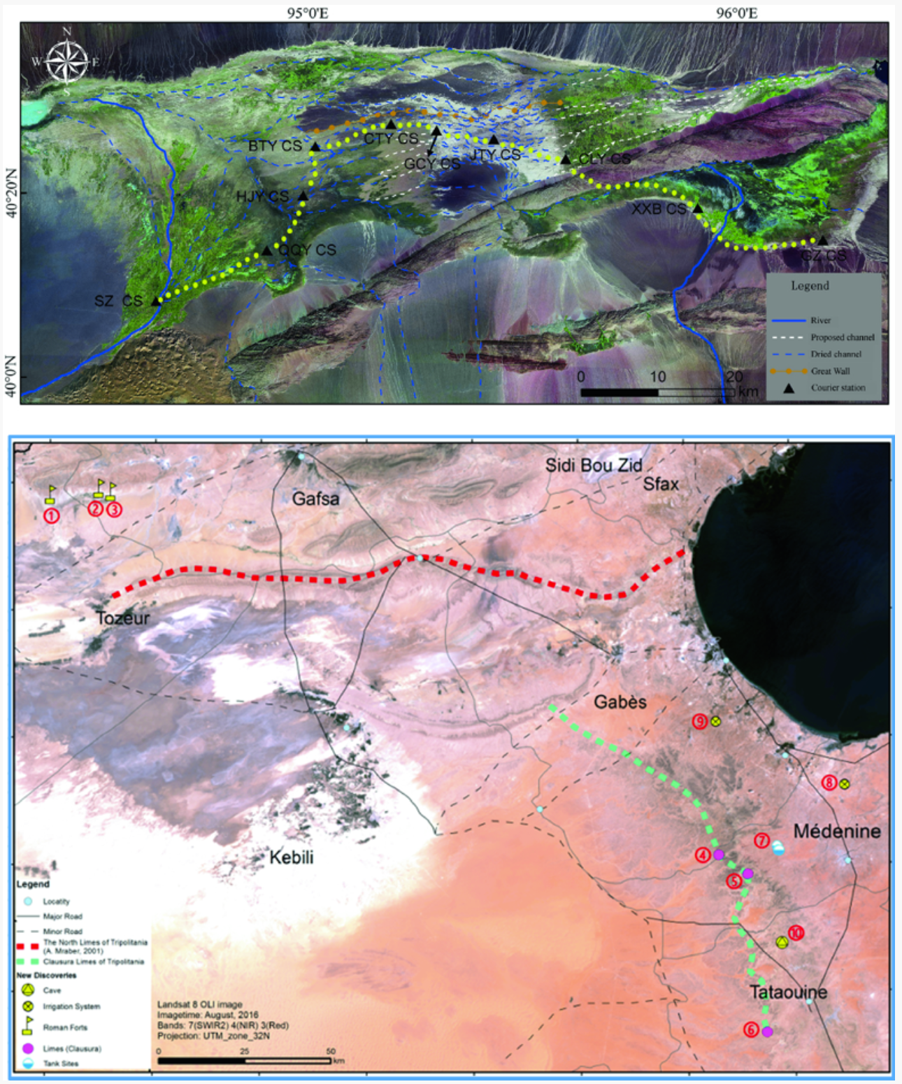
Figure3. Space archaeology of the silk road in China (upper) and Southern Tunisia (lower)
Cultural Heritage Monitoring and Protection
By comparing with spatial archaeological detection (which can be traced back to remote sensing archaeology), there is still a lack of research in the methodology and applied strategy of spatial technology employed for heritage monitoring and protection. The existing work on the monitoring of the heritage ontology and environment is often isolated and the monitoring elements and means are relatively simple, which affects the comprehensive understanding and systematic response to the sustainable protection of cultural heritage. Recently, from the perspective of UN Sustainable Development Goals 11 and 8, CAS’s space archaeology research group proposed that geospatial information technology such as photogrammetry, remote sensing and spatial information would play an important role in defending and protecting cultural heritage and sustainable tourism. CAS’s space archaeology research group developed a two-scale radar interferometry method and model for deformation monitoring and health diagnosis of heritage sites affected by disease (Figure 4) that considered the dynamic changes in heritage ecosystems, monitored environmental factors (including urbanization, forest degradation, land use, groundwater level) to resolve the current controversy surrounding the potential structural collapse of monuments in Angkor. They constructed the dynamic model of the disease evolution of the Angkor temple complex and unveiled the mystery of the decline of the heritage site, bringing a new insight for the site sustainable conservation.
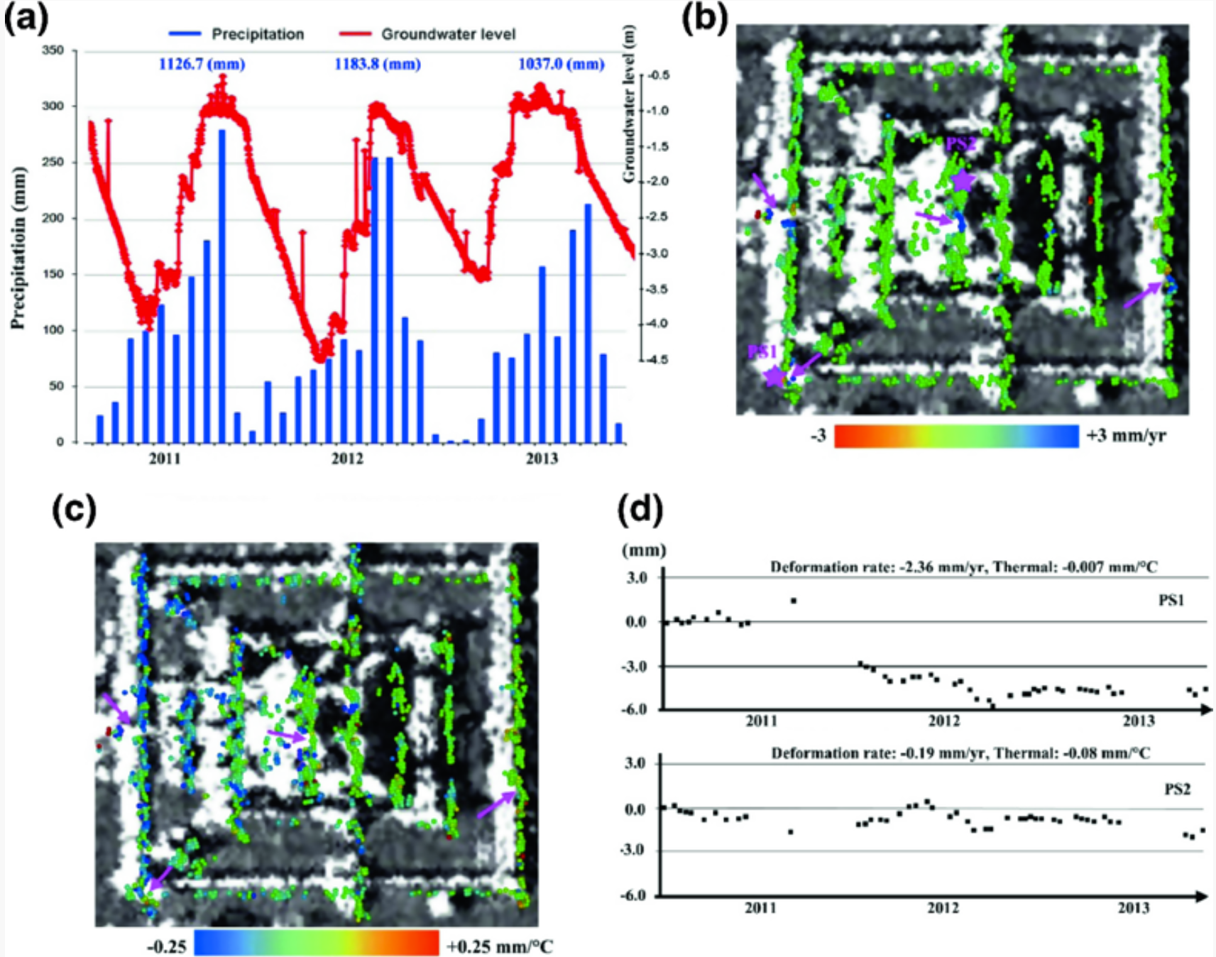
Figure 4. Angkor’s environmental remote sensing revealed the collapse of ancient temples and contributed to the sustainable protection of heritage sites.