Alpine regions are important for riverine and watershed ecosystems as they are a source of freshwater that providing for, and stimulate specific habitats and support biodiversity. In parallel, recent climate change, human activities and other perturbations may disturb hydrological processes and eco-functions in these areas, creating the need for a next-generation of observational and modeling approaches towards predictive understanding of vital processes in the alpine region. However, there are several challenges, including the cold and harsh climate, high altitude and complex topography, that inhibit complete and consistent data collection where and when it is needed, which hinders the development of remote sensing technologies, method and hydrological models in alpine regions.
The current study presents a suite of datasets consisting of long-term hydro-meteorological, snow cover and frozen ground data and modelling functions in an integrated, distributed and multi-scale observation network in the upper reaches of the Heihe River Basin (HRB) in China. Gap-free meteorological and hydrological data were obtained by connecting a group of 25 automatic meteorological stations (AMSs) forming an observational network. In addition, to capture snow accumulation and ablation processes, snow cover properties were collected from a snow observation super-station using state-of-the-art techniques and instruments. High-resolution soil physics datasets were also obtained to capture the freeze-thaw processes from a frozen ground observation super-station. The updated datasets were released to scientists and can be used for research into a wide variety of disciplines and multidisciplinary analysis. The dataset is expected to be used as a testing platform for reliable forcing data for evaluation and validation of remote sensing products and hydrological models for the scientific community. The datasets are available through the Big Earth Data Platform for Three Poles (poles.tpdc.ac.cn/en/).
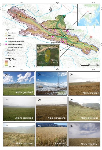
The integrated hydrometeorological-snow-frozen ground observation network located at the study site
Reference: Che,T., Li, X., Liu, S., Li, H., Xu, Z., Tan, J., Zhang, Y., Ren, Z., Xiao, L.,Deng, J., Jin, R., Ma, M., Wang, J., Yang, X. Integrated hydrometeorological,snow and frozen-ground observations in the alpine region of the Heihe RiverBasin, China. Earth System Science Data, 2019, 1-16,https://doi.org/10.5194/essd-2019-11.