


Scale: Regional
Study area: Southeast Asia
Mangrove forests are swampy woody plant communities that from natural disasters such as hurricanes and tsunamis.
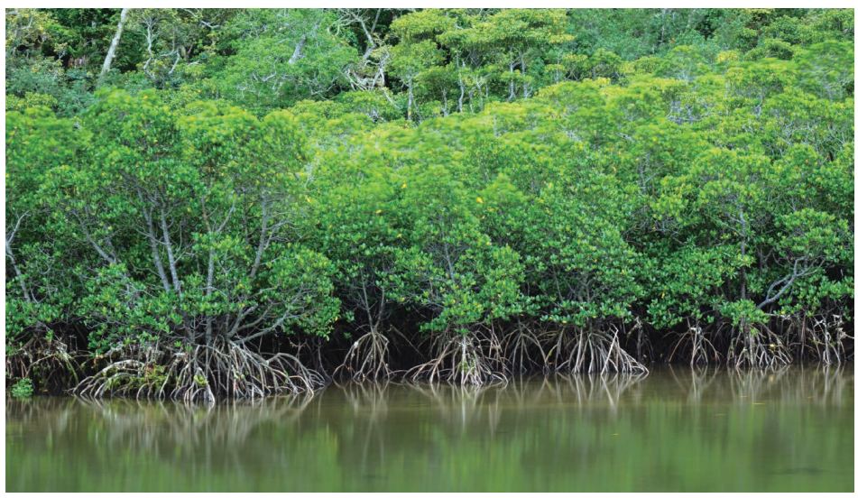
Mangrove forests are swampy woody plant communities that grow on the intertidal zone of tropical and subtropical coasts.They have special sea-land characteristics and enormousecological, economic, and social benefits. Mangrove forestsplay an important role in highlighting global climate andenvironmental changes. Additionally, they are important formaintaining biodiversity, protecting coastal environments,purifying coastal waters, and protecting farmland and villages from natural disasters such as hurricanes and tsunamis. The distribution of mangroves along the Maritime Silk Road accounts for more than half of the world’s total mangrove forest area. They are mostly located in tropical-subtropical regions with Southeast Asia having a large mangrove forest area. Currently, mangrove forests in the coastal areas of Southeast Asia are under threat from ecological disturbances and are experiencing continuous degradation.
|
|
Mangrove forests are swampy woody plant communities that grow on the intertidal zone of tropical and subtropical coasts.They have special sea-land characteristics and enormousecological, economic, and social benefits. Mangrove forestsplay an important role in highlighting global climate andenvironmental changes. Additionally, they are important formaintaining biodiversity, protecting coastal environments,purifying coastal waters, and protecting farmland and villages |
|
The distribution of mangroves along the Maritime Silk Road accounts for more than half of the world’s total mangrove forest area. They are mostly located in tropical-subtropical regions with Southeast Asia having a large mangrove forest area. Currently, mangrove forests in the coastal areas of Southeast Asia are under threat from ecological disturbances and are experiencing continuous degradation. |
|
Target 6.6: By 2030, protect and restore water-related ecosystems, including mountains, forests, wetlands, rivers, aquifers, and lakes. |
| Indicator 6.6.1: Change in the extent of water-related ecosystems over time. |
| Method |
This case study employed long-term time series remote their spectral characteristics, textural features, and spatial
sensing data obtained from Landsat satellites to monitor configuration with references from Google Earth images for the
dynamic changes in mangrove forests in Southeast Asia from same period. These areas were then vectorized and mapped.
The 1990 to 2015. The satellite images were first pre-processed results of this study were compared with the existing mangrove
using radiometric calibration, and atmospheric correction and datasets provided by FAO and World Mangrove Forests (WMF).
registration. The mangrove areas were then identified using.
| Data used in the case |
◎ A total of 1,836 Landsat Thematic Mapper (TM) and Enhanced Thematic Mapper Plus (ETM+) images from 1990 to 2015
were used for long-term change monitoring of mangrove forests.
◎ FAO and WMF mangrove datasets were used to verify the accuracy of results.
| Results and analysis |
The top three countries with the largest area of mangroves in the Philippines, Thailand, Myanmar, Indonesia, Malaysia, and
Southeast Asia were Indonesia (68%), Malaysia (10%), and Cambodia were observed to continue to decrease, while the
Myanmar (9%) (Figure 3-7). During the period from 1990 to areas in Singapore remained unchanged. China’s mangrove area
2015, the area of mangrove forests in Southeast Asia revealed a was observed to slightly increase in recent years. (Figure 3-7).
decreasing trend (Figure 3-6). The mangrove areas in Vietnam,
Big Earth Data in Support of the Sustainable Development Goals
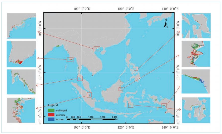
Figure 3-6. The change in mangrove area in Southeast Asia from 1990 to 2015.
The mangrove forest area in Southeast Asia was observed environmental pollution, further damaging mangrove wetland
to decrease from 1990 to 2015, especially in Vietnam, the habitats and decreasing their total surface area. Conversely,
Philippines, Thailand, Myanmar, Indonesia, Malaysia, and China’s mangrove area has been observed to be increasing in
Cambodia. This was caused by the rapid economic development recent years, reflecting the nation’s emphasis on ecological
in Southeast Asia, especially in Vietnam and Thailand. and environmental protection, and implementation of relevant
Aquaculture has been vigorously developed, resulting in the policies. Such policies include returning ponds to forests and
accelerated loss of mangrove wetlands and their transformation wetlands, which leads to an increase in the area of mangrove
into aquaculture ponds. Meanwhile, aquaculture has enabled wetlands.
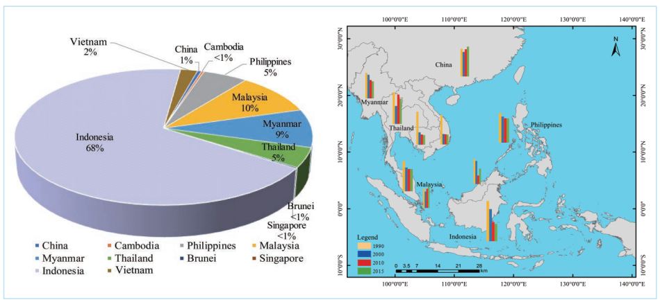
Figure 3-7. Distribution and change in mangrove area in Southeast Asian countries from 1990 to 2015.
SDG 6 Clean Water and Sanitation
Highlights
During the period from 1990 to 2015, the area of mangrove forests in Southeast Asia has revealed a
decreasing trend. The mangrove areas in Vietnam, the Philippines, Thailand, Myanmar, Indonesia,
Malaysia, and Cambodia continue to decrease, while the area in Singapore remains unchanged.
China’s mangrove area has slightly increased in recent years.
Recently, the area of mangrove forests in China has shown an increasing trend, reflecting the
effectiveness of conservation measures such as returning ponds to forests and wetlands.
| Outlook |
Mangrove wetlands are open, fragile, and complex ecosystems. (1) Mangrove forests will be monitored using multi-source
They grow in coastal areas where economic development remote sensing data. High-resolution, hyperspectral, and radar
occurs at a rapid pace. In addition to the influence of natural remote sensing data will be used for monitoring mangrove
factors, human activities directly and indirectly affect the forests. Moreover, deep-learning methods will be used to
growth, distribution, health, and diversity of mangrove forests. enhance the identification and extraction of mangrove forests
The dynamic change in mangrove area reflects human activity from remote sensing imagery.
|
such as the restoration and protection of mangroves, and their encroachment and use. Moreover, the change in mangrove area is directly linked to economic and social sustainable development and the implementation of relevant policies. Future developments will involve a focus on the following aspects. |
(2) There will be a focus on providing data and information support for the protection, restoration, and rational use of mangrove resources in the region. |
Mangrove forest