


Scale: Global
Study area: Global
Land degradation is a serious global ecological problem that directly affects the survival and development of 250 million people in developing countries. This issue will likely be intensified due to climate change and population growth.
Big Earth Data provides several advantages for developing an assessment method at different scales to examine the distribution and severity of land degradation.
| Target 15.3: By 2030, combat desertification, and restore degraded land and soils, including land affected by desertification, drought, and floods, and strive to achieve a land degradation-neutral world. |
| Indicator 15.3.1: The proportion of degraded land to the total land area. |
Three sub-indicators, including land cover, productivity, and soil carbon content, were selected for analysis and calculated using Big Earth Data at global scales. Analysis was performed following the GPG (Good Practice Guidance in SDG 15.3) issued by the United Nations Convention to Combat Desertification (UNCCD). These indicators were used to globally assess land degradation/improvement from 2000 to 2015, designated as the baseline period by the UNCCD Scientific Conceptual Framework for Land Degradation Neutrality (LDN-SCF). The land cover sub-indicator was calculated by analyzing dynamic changes in the second stage of the Climate Change Initiative Land Cover (CCI-LC). The soil carbon sub-indicator was evaluated using empirical conversion coefficients according to the Intergovernmental Panel on Climate Change (IPCC) report. The net primary productivity indicators were calculated by combining trends, status, and performance based on MODIS’s enhanced vegetation index (2000-2015). Finally, the three sub-indicators were integrated based on the 1OAO (1 Out All Out) principle.
- Land cover imagery from 2000 and 2015 with a 300-meter spatial resolution provided by the European Space Agency (ESA).
- MODIS Enhanced Vegetation Index (2000-2015) with a 250-meter spatial resolution provided by NASA.
- Soil Carbon (0-30 cm) data with a 250-meter spatial resolution provided by International Soil Reference and Information Centre (ISRIC).
- RESOLVE Ecoregions 2017.
The results of the land degradation and recovery are displayed in Figure 1. Land degradation was observed to mainly occur in Central Asia, Western Australia, the central part of South America, and the northern part of North America. Land recovery mainly occurred in China, India, and Europe.
According to statistics, the global improved land area was 9.83 million km2 and the land degradation area was 3.43 million km2 between 2000 and 2015. The overall improved land area was greater than the land degradation area, but there was a significant difference in its spatial distribution. A total of 148 out of 195 countries featured a greater improved land area in comparison with degraded land area. Moreover, 15 countries had an equal amount of change, and 32 countries featured more land degradation than land improvement. Thus, there are still serious challenges facing the realization of SDG 15.3 in 2030. China’s land improvement area was observed to be larger than its land degradation area, and the net land improvement area (e.g., the improvement area minus the degraded area) was 1.17 million km2. This confirms the “realization of land degradation neutrality in advance” from the perspective of Big Earth Data. Additionally, China’s net land improvement area accounted for 18.24% of the world’s total improved area (ranking first in the world), making an important contribution to global land degradation neutrality.
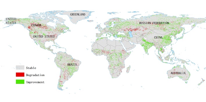
⬆ Figure 1. Global land degradation and improvement map (2000-2015).
| Highlights |
|
The indicator’s low spatial resolution is the biggest limitation for global SDG 15.3.1 assessment. High-resolution evaluation indicators (>30 m) are currently being developed that uses higher resolution datasets.
The dynamics of land productivity are greatly affected by climatic factors. Thus, it is necessary to develop corresponding correction methods and a land productivity assessment method that separates the effects of climate fluctuations.